
With more than 800 miles of coastline, California is blessed with some of the most spectacular beaches in the world. But while places like Santa Monica and Huntington Beach often grab the headlines, some of California’s most memorable coastal destinations are the ones that feel completely different from a typical beach experience. If you’re looking to explore beyond the usual sun-and-surf destinations, these are some of California’s Most Amazing and Unique Beaches.
Some feature purple sand. Others hide shipwrecks, waterfalls, elephant seals, sea caves, or towering cliffs. A few feel more like scenes from another planet than a stretch of California coastline.
But they are all worth a visit as you explore our amazing coast.
Glass Beach
Fort Bragg
At first glance, Glass Beach, just north of Mendocino, looks like a normal Northern California beach. Then you notice the colorful pieces of smooth sea glass scattered across the shoreline.
The glass is the result of decades-old dumping practices that would never be allowed today. For 61 years, from 1906 after the Loma Prieta Earthquake, until 1967, residents dumped their trash on this beach. Then the California State Parks came in and closed it to dumping and cleaned up the larger metal and automotive parts. The beach came back to a nearly pristine condition; except for the glass, which was too small to collect. Over time, the ocean transformed broken bottles and discarded glass into polished gems that sparkle in the sunlight.
While collecting glass is prohibited, and Glass Beach is protected as part of MacKerricher State Park, walking the beach and admiring nature’s unexpected recycling project is well worth the trip.
How to Get There: The beach and park are three miles north of Fort Bragg on Highway 1, near the town of Cleone.
McWay Falls Beach
Big Sur

If there’s one beach in California that feels almost unreal, it’s the tiny cove beneath McWay Falls. Here, an 80-foot waterfall spills directly onto a secluded beach framed by turquoise water and dramatic Big Sur cliffs. The beach itself is protected and not accessible to the public, but that’s part of what makes it so special—the view from the overlook feels like looking into a hidden paradise.
Unlike most California beaches, the attraction here isn’t swimming or sunbathing. It’s the sheer uniqueness of seeing a waterfall meet the Pacific Ocean in one of the most photographed landscapes on the West Coast.
What makes it unique:
- One of the few coastal waterfalls in California that flows directly onto a beach
- Stunning turquoise cove
- Easy access from Julia Pfeiffer Burns State Park
- Exceptional sunrise and sunset photography
Walking required: Approximately 0.5 miles round trip on an easy, well-maintained overlook trail. Early morning or late afternoon when the lighting enhances the colors of the cove and the crowds are smaller.
How to Get There: Take the Falls Trail just past the entrance to Julia Pfeiffer Burns State Park. You’ll pay a day use fee to park here, but the Falls Trail goes under Pacific Coast Highway via a tunnel, making it a safer option. There is no beach or ocean access allowed at McWay Falls. Attempting to reach the sand is strictly prohibited.
Pfeiffer Beach
Big Sur
Pfeiffer Beach is one of California’s most photographed stretches of coastline—and for good reason. The beach is famous for its unusual purple sand, created by manganese deposits in the surrounding hills. Depending on recent rainfall and wave conditions, streaks of purple can be seen mixed throughout the sand.
Add in dramatic sea stacks and the famous Keyhole Rock arch, and it’s easy to understand why photographers flock here at sunset.
How to Get There: Beach can be hard to find, but if heading south on Hwy 1, it is the second road after Pfeiffer State Park on the right. $10 fee for parking.
Bowling Ball Beach
Schooner Gulch State Beach, Mendocino County

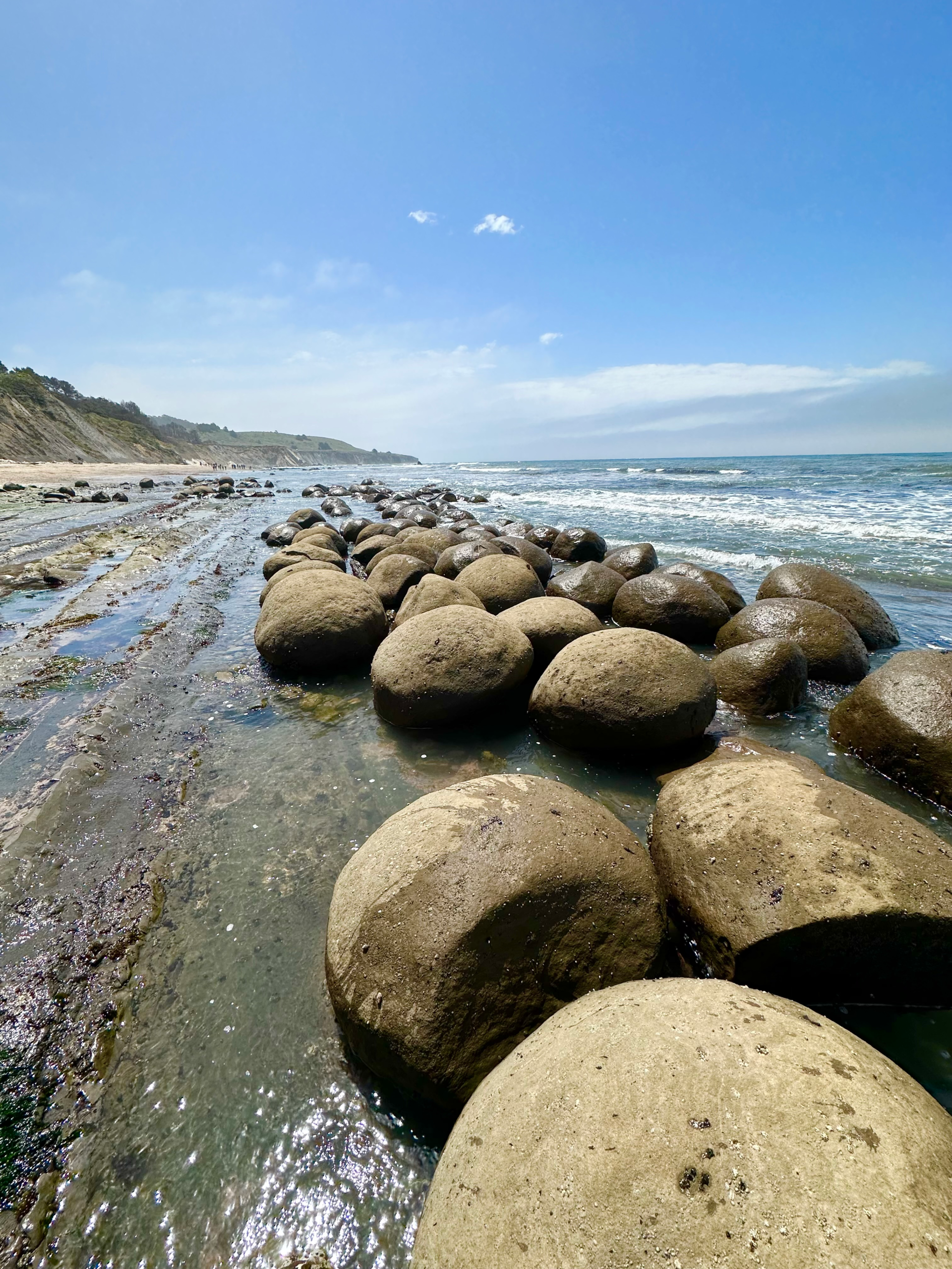
No, there aren’t giant bowling balls rolling around the shoreline. But this beach does feature dozens – or hundreds of nearly perfect spherical rock formations lined up along the coast. During low tide, they emerge from the surf in neat rows, creating one of California’s strangest geological sights.
The formations are entirely natural, formed by a geological process called concretion. Over millions of years, mineral cements hardened around organic objects, while ocean waves eroded the surrounding softer cliffs to leave the spheres behind. They provide a fascinating glimpse into the forces that shape our coastline.
How to Get There: The beach’s actual name in Schooner Gulch State Beach, which is right on Rte 1, 10 miles north of Gualala.
Black Sands Beach
Shelter Cove, Lost Coast
There are actually 2 famous Black Sands Beaches of note. The first one is a hidden beach in the Marin Headlands off Alexander Avenue, just over the Golden Gate Bridge from San Francisco. This Beach is stunning and totally private, with a steep, rocky climb down.
But the bigger and possibly more famous one is north, on California’s Lost Coast. This area already feels like another world, and Black Sands Beach only adds to the experience. The 3.5-mile stretch of dark pebbly sand is often cited as the largest black sand beach in the state.
Dark volcanic sand stretches beneath steep coastal mountains, creating a striking contrast with the crashing Pacific waves. This is not a beach for amusement parks, boardwalks, or beach umbrellas. Because it is some 4 hours north of San Francisco, this can be a place for solitude, hiking, and appreciating one of the most untouched sections of coastline in the state.
How to Get There / Access: End of Beach Road in Shelter Cove; it serves as the southern trailhead for the rugged Lost Coast Trail
Tennessee Cove
Marin Headlands

Hidden within the Marin Headlands, Tennessee Cove rewards visitors willing to hike a little.
The beach itself is beautiful, surrounded by steep green hills and rugged cliffs. But what makes it truly unique is its history. This is where the steamship SS Tennessee ran aground in 1853, giving both Tennessee Valley and Tennessee Cove their names.
On rare occasions, remnants of the wreck can still emerge from the sand.
How to get there: Traveling north from San Francisco, head over the Golden Gate bridge and where 101 and Rte. 1 split, stay on Rte. 1. Take the Tennessee Valley Road exit and follow it to the end. There is a 1.8 mile hike on the well-groomed Tennessee Valley Trail from the trailhead to the beach. There is both an upper and lower trail – the upper offers stunning views from the bluffs but is a bit more difficult of a climb down to the beach.
Marshall’s Beach
San Francisco

Most visitors to San Francisco never make it here, which is exactly why it belongs on this list.
Marshall’s Beach offers one of the most spectacular views of the Golden Gate Bridge anywhere in the city. Towering cliffs, crashing surf, and the bridge rising above it all create an unforgettable setting.
The hike down keeps crowds manageable, making it feel surprisingly secluded despite being within city limits.
How to get there: Marshall’s Beach is right at the northernmost part of San Francisco, before heading over the Golden Gate Bridge. From either Rte. 1 or 101, Exit Lincoln Boulevard just before you get to the bridge. Follow Lincoln to the Presidio and turn onto Langdon Court. Just further on Lincoln is Baker Beach, another great stop with killer views of the bridge on your beachy tour.
Rodeo Beach
Marin Headlands

Rodeo Beach is one of California’s most unusual beaches because of what you’ll find beneath your feet. Instead of traditional sand, much of the beach is covered in colorful pebbles and stones. On sunny days, the shoreline sparkles with reds, greens, blues, and black stones polished smooth by the ocean.
It’s also a great place within a close proximity to San Francisco for birdwatching, photography, and coastal hiking.
How to get there: Traveling north from San Francisco, head over the Golden Gate bridge and take the first exit, Alexander Avenue. Turn left onto Bunker Road and go under the freeway. Bunker Road takes you all the way to Rodeo Lagoon and Rodeo Beach.
Point Lobos Hidden Beaches
Carmel

The beaches tucked inside Point Lobos State Natural Reserve aren’t large, but they may be among the most beautiful in California.
Tiny coves, turquoise water, dramatic cliffs, sea lions, otters, and Monterey cypress trees combine to create scenery that often feels more like New Zealand than California.
China Cove is particularly stunning and often leaves visitors wondering why it isn’t more famous.
How to get there: Point Lobos is accessed right from Highway 1. Traveling south from San Francisco you won’t miss it on the left just past Carmel
Sand Dollar Beach
Big Sur
Big Sur is full of remarkable coastal scenery, but Sand Dollar Beach stands apart because it’s one of the region’s few larger sandy beaches.
Surrounded by towering cliffs and coastal bluffs, it offers a rare opportunity to walk a long stretch of sand while taking in Big Sur’s iconic scenery.
It’s especially popular with surfers and beachcombers.
How to get there: Sand Dollar Beach is deep into the Big Sur coast. Traveling from Carmel, pass the Big Sur Lightstation, travel past Paul’s Slide. Sand Dollar Picnic area and Beach is a dirt parking lot with a kiosk ($10 for parking) marked with a sign.
Coronado Beach
San Diego
At first glance, Coronado Beach may seem less unusual than some others on this list.
Then the sunlight hits the sand.
The beach contains mica deposits that give the sand a shimmering, almost golden appearance. Combined with the backdrop of the historic Hotel del Coronado and the wide, flat shoreline, it creates one of Southern California’s most beautiful beach experiences.
How to get there: If coming from the south you can take the Silver Strand. If from the north, take the Coronado Bridge and follow the signs.
Shark Fin Cove
Davenport

A massive sea stack shaped remarkably like a shark’s fin gives this beach its name.
Located north of Santa Cruz, Shark Fin Cove features dramatic cliffs, caves, and one of the most photogenic coastal landscapes on the Central Coast. Although you can take some awesome photos from the cliffs above, the view from the beach is even more stunning, and the short hike down to the beach adds to the sense of discovery.
After you’ve snapped a bunch of photos of the sharkfin from the beach, you can go to the southern side of the beach and take in the dramatic sea window and watch the waves roll through the open archway.
Then head to the north side and explore the cave. It goes back quite a way and is very dark; make sure you have a flashlight or your phone.

How to get there: If traveling northbound from Santa Cruz, pass by Rodoni farmstand. After passing Bonny Doon Road (and Bonny Doon Beach), Use the next pullout on the left. There is a new pullout right across from Bonny Doon Road, but that’s not the right one. Go to the next one on the left. If traveling southbound from Half Moon Bay, the pullout is the second one after Davenport town. It is a short hike to the beach with stunning views.
Moonstone Beach
Cambria

Moonstone Beach is one of the best beachcombing destinations in California.
Named for the colorful stones that wash ashore, it’s a wonderful place to stroll, watch waves, and enjoy the rugged beauty of Cambria and the Central Coast. The elevated boardwalk provides excellent views, and migrating whales can often be spotted offshore.
It’s a favorite stop on Highway 1 road trips.
How to get there: From Highway 1, turn onto Windsor Boulevard (at the light) toward the ocean. Make an immediate right onto Moonstone Beach Drive.
Enderts Beach
Redwood National Park
How many beaches let you walk from ancient redwood forests directly to the Pacific Ocean?
Enderts Beach does exactly that.
Located within Redwood National Park, this remote beach combines tide pools, sea stacks, and wild coastline with some of the tallest trees on Earth nearby. It perfectly captures California’s incredible geographic diversity.
The Magic of California’s Coast
What makes California’s beaches so special isn’t just their beauty—it’s their variety. In a single state, you can stand on purple sand, explore hidden coves, photograph colorful pebbles, discover shipwrecks, walk among sea stacks, and watch waves crash beneath towering redwoods.
The next time you’re planning a California road trip, consider venturing beyond the most famous beaches. Some of the state’s most memorable coastal experiences happen where the crowds thin out, the scenery gets a little wilder, and every bend in the road reveals something unexpected; these are California’s Most Amazing and Unique Beaches.